The discussion below explains the significance of including only the Pacific States as the source of the Progressive Pacific Message. Certainly it is partly due to the Progressive politics of these states, but it has more to do with the history and population makeup. Simply it is cultural, and folks in Iowa and South Carolina know there is a significant difference though most know not why.
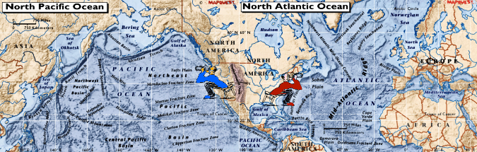
The word "Pacific" is included in The Progressive Pacific Message because the beaches of the four Pacific States - Hawaii, Washington, Oregon, and California - are on the Pacific Ocean. The Pacific States came into the United States with views to the west from San Francisco towards China, to the north from Seattle towards what was Russian Alaska, and to the south from San Diego towards Mexico.
You can walk the Pacific Coast of the continent from the Southern tip of Chile to Alaska. You can sail from a harbor directly across an ocean to Japan, North Korea, or China because it is the Pacific Ocean.
Yes, it is 2,827 driving miles from San Diego east to New York City. But, it's also only 2,819 driving miles from San Diego, California, to San Salvador, El Salvador.
Some troubling truths for the people of the Pacific States in 21st Century America are:
- The history of the Pacific States is ignored by Americans living east of the Transcontinental Divide who have a North Atlantic cultural orientation and who misrepresent their region's history.
- The history derived from the 18th and 19th Century U.S. policies of slavery, religious bigotry, and genocide is routinely misrepresented by those living east of the Transcontinental Divide, literally resulting in discrimination and recriminations against Pacific State people who protest established U.S. politicians and institutions systemically continuing those misrepresentations.
- An extreme cultural separation from those east of the Transcontinental Divide exists resulting in continuing discrimination against Pacific State residents the majority of whom are descendants of
- indigenous peoples of the Americas and the Pacific and
- Asian immigrants.
- The economies of the Pacific States are under attack from Americans who live east of the Transcontinental Divide.
- The defense of the Pacific States, through both strategies in international relations and the military, ranges from secondary-in-importance to incompetent to non-existent.
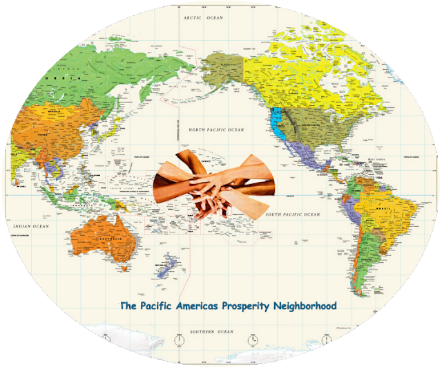
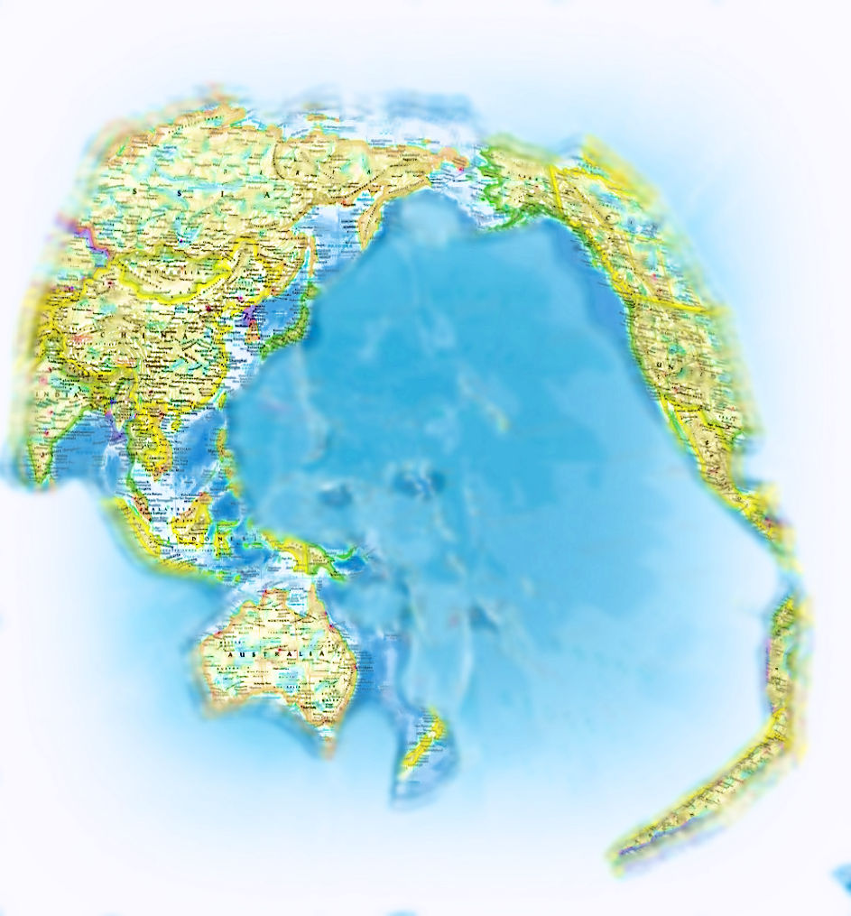 The
Pacific States view of the world as represented in the graphic to the
right, a likely 21st Century worldview vision, is a different cultural orientation
from that which dominated the United States from the 17th through the
20th Centuries. That Pacific States view results
from:
The
Pacific States view of the world as represented in the graphic to the
right, a likely 21st Century worldview vision, is a different cultural orientation
from that which dominated the United States from the 17th through the
20th Centuries. That Pacific States view results
from:- a history based upon not being anywhere near the Atlantic Ocean,
- an economy built upon Pacific trade routes,
- a majority population that includes persons who identify themselves as Hispanics, Asian, Indigenous, Black, and/or Mixed Race, and
- because of an Atlantic-focused ideological myopia, for the second time in a century a dangerous, inadequate U.S. international policy and military defense preparation and activities (the first time in 1941 was the only time a Pacific State was attacked by a foreign military).
- attack on the human rights of the 51 million people of the Pacific States,
- denial of the Progressive beliefs of the Pacific States majority,
- assault on the economy of the Pacific States, and
- failure to provide defense planning to protect the Pacific States.
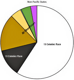
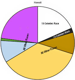
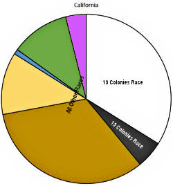
Population by Race/Ethnicity

To provide some shared context we will note what makes the Pacific States different and Progressive. History, geography, and economics matter far more than ideals.- Consider that the Louisiana Purchase in 1803 passed in the House of Representatives by a vote of 59-57 because...
- the power of the Atlantic seaboard states would be threatened by the new citizens in the West, whose political and economic priorities were bound to conflict with with those of East Coast merchants and bankers, and
- the Atlantic seaboard voters (white male landowners) opposed the granting citizenship to the Catholic French and Spanish speaking residents, as well as free Black residents, of New Orleans as the treaty required.
- Consider that California has a larger Hispanic population than 44 other states each have people (yes, total people, everyone in each of those states) and a larger Asian population than 25 other states have people, yet California has only two U.S. Senators while those other states have 88 and 50 respectively; non-Hispanic white people and black people* (the 13 Colonies Races) together make up only 39% of California's population.
- Consider that in Hawaii non-Hispanic white people and black people* together (the 13 Colonies Races) make up only 20% of the population and that Asian residents make up 36% of the population.
- Consider the pie charts comparing the 46 other states to the
Pacific States without the white and black segments, the 13 Colonies Races*,
- Consider that imports and exports at the 28 ports along the West Coast totaled over $630 billion in 2014, including smaller ones like Kalama , Washington (total 2014 trade $3.0 billion, top export Soybeans, top import Rolled iron and steel); and consider that the voters in states like Michigan which has a population that is 88% 13 Colonies Races have abandoned trade patterns and proposals
such as the Trans-Pacific Partnership that would have benefitted such ports.
- Consider the Muslim terrorist threat that so worries those East of the Intercontinental Divide in a factual context:
- The country with the largest Muslim population in the world is a Pacific Rim country - Indonesia.
- The country which provides the most crew members on merchant ships delivering goods - both necessities and fripperies - to the United States ishome to the world's 30th largest Muslim population (larger than Somalia) and is a Pacific Rim Country that has been engaged in a war with the Islamic State East Asia (ISEA) for two decades in which U.S. troops participated from 2002 to 2015 - The Philippines.
- China has a Muslim population of 25± million (that's more people than live in each of the 17 least populous U.S. states) with about 16 million living in the Xinjiang Uygur Autonomous Region (that's more people than live in each of the 14 least populous states) which Muslims have a very long history of violence - China is the subject of criticism in the American press because it currently has incarcerated 5%± of its Muslim population (which is about twice the number of incarcerated illegal immigrants in the U.S., mostly Spanish-speaking descendants of the indigenous populations of the Americas) even though the U.S. has roughly four times the number of people incarcerated per 100,000 of its people.
- Regarding significant military capabilities, in addition to China and Russia which are both Pacific Rim countries, North Korea has had the ability to attack the Pacific States with missiles since the beginning of the 21st Century, first with submarines and by 2013 with ICBM's.
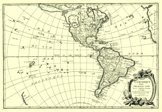
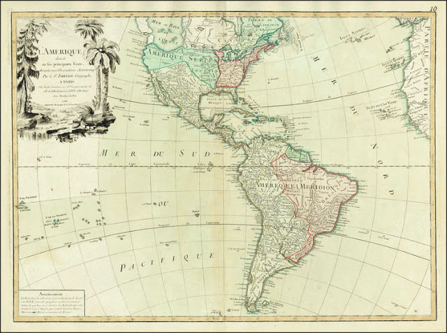
The images above are the continent of "L' Amerique" mapped by by Jean (aka Robert) Janvier, a Paris-based cartographer active in the 18th century. By the late 18th century Janvier was awarded the title of "Geographe Avec Privilege du Roi" and this designation appears on these maps. Janvier worked with many of the most prominent French, English and Italian map publishers of his day.
The map at the top was completed and sold in the 1760's before the Revolutionary War, the one at the bottom in 1790, during the first year of the United States government.
From the maps one can see that to the west of the continent of "L' Amerique" is the "Mer du Sud ou Mer Pacificque." While Janvier didn't see a need to provide the name for the "Mer du Nord" (Atlantic Ocean) on the map, he found it necessary to provide the name of the Pacific Ocean.
That was because in the 18th Century the Pacific Ocean was an unknown curiosity and irrelevant to most Europeans other than the Spanish. (From this point on, Spain and Spanish will be emphasized to help the reader understand that Britain and English were unimportant to the Pacific Coast of North America.)
Effectively, the Pacific Ocean did not exist for Europeans prior to the 16th Century. And in the 16th, 17th, and 18th Centuries (1500's through the 1700's), it was not important to Americans as well as to most Europeans other than the Spanish.
Though the peoples of Asia and Oceania have traveled the Pacific Ocean since prehistoric times, the eastern Pacific was first sighted by Europeans in the early 16th century when Spanish explorer Vasco Núñez de Balboa crossed the Isthmus of Panama in 1513 and discovered the great "southern sea" which he named Mar del Sur (in Spanish), a designation indicated on the maps above.
However, it was Portuguese explorer Ferdinand Magellan who in 1521, during the his circumnavigation of the world on behalf of Spain, upon encountering favorable winds named it Mar Pacífico, which in both Portuguese and Spanish means "peaceful sea." The word "pacific" derives from the Latin pācificus meaning "peace-making." During that 1521 voyage, Magellan "discovered" the Philippines and claimed them for Spain.
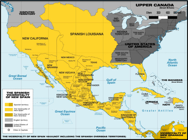
Also in 1521 the Spanish conquered the Aztec Empire and, following some additional conquests, in 1535 Spain created the Viceroyalty of New Spain. In fact, in 1789 when the U.S. Constitution became effective, contrary to the 1790 map above created by a French citizen, the map of New Spain looked like this...
On October 1, 1800, First Consul of the Republic of France Napoleon Bonaparte, reacquired Louisiana from Spain by the secret Treaty of San Ildefonso. To the distress of the United States, Napoleon held title to the Mississippi River and the port of New Orleans.
In 1803 with some sense of urgency, President Thomas Jefferson and Secretary of State James Madison secured the Louisiana Purchase in the face of considerable opposition. As explained in part in Wikipedia:
Both Federalists and Jeffersonians were concerned over thepurchase's constitutionality. Many members of the House of Representatives opposed the purchase. Majority Leader John Randolph led the opposition. The House called for a vote to deny the request for the purchase, but it failed by two votes, 59–57....Slaveholder President Thomas Jefferson placed a special importance on declaring U.S. total sovereignty over this land occupied for centuries by the many different indigenous Native American communities. Immediately after the Louisiana Purchase he commissioned fellow slaveholders Meriwether Lewis and William Clark to carry out the Lewis and Clark Expedition; the three year Corps of Discovery Expedition (as it was known then) crossed the Transcontinental Divide of the Rocky Mountains, camping near the Pacific Ocean in the winter of 1805-1806.
The Federalists also feared that the power of the Atlantic seaboard states would be threatened by the new citizens in the West, whose political and economic priorities were bound to conflict with those of the merchants and bankers of New England....
Another concern was whether it was proper to grant citizenship to the French, Spanish, and free black people living in New Orleans, as the treaty would dictate. Critics in Congress worried whether these "foreigners", unacquainted with democracy, could or should become citizens.
It should be noted that William Clark went on in official positions to implement President Andrew Jackson's Indian removal (aka genocide) policy, even issuing an extermination order that read:
The faithless and treacherous character of those at the head of our Indian enemies appear now to be so well known and understood, as to permit the expression of the hope, that their wanton cruelties will eventually result in their own destruction; and aa they have afforded sufficient evidence not only of their entire disregard of Treaties, but also of their deep-rooted hostility in shedding the blood of our women and children, a War of Extermination should be waged against them. The honor and respectability of the Government requires this: - the peace and quiet of the frontier, the lives and safety of its inhabitants demand it.At that time there were still conflicting claims on the area designated as "Oregon Country." However, despite having fought the Revolutionary War and the War of 1812 against England, the area of what are now the states of Oregon and Washington were included in the Oregon Territory, initially defined by the Treaty of 1818 that set up a "joint occupation" between the United States and the British over the region. In 1848 the Oregon Territory became an organized incorporated territory of the United States. The Washington Territory was split off in 1853.
After a protracted struggle (1810–21) for independence, New Spain - including the current U.S. states of California, Nevada, Utah, Arizona, New Mexico, Texas, and parts of Oklahoma, Kansas, Colorado and Wyoming - became the sovereign nation of Mexico, with the signing of the Treaty of Córdoba. (At this point, terms related to "Mexico" will also be emphasized to help place that country's context in U.S. history.)
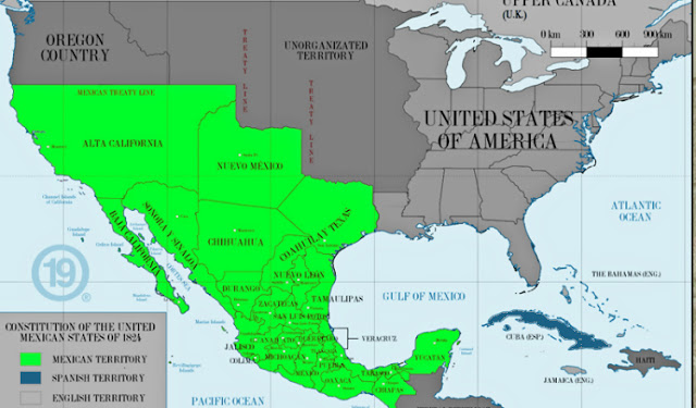
California was part of Mexico for 27 years until the Mexican-American War beginning on May 13, 1846, ending with the Treaty of Guadalupe Hidalgo in 1848. California was admitted to the Union as a state in 1850. But it should be noted that prior to the War, Pío de Jesús Pico IV, the last governor of Alta California, as with a significant number of influential Californios, was in favor of British annexation.
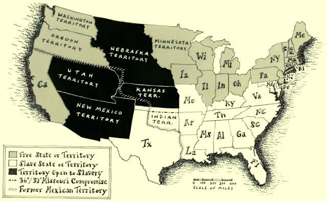
Thus, by the beginning of the Civil War the map of what is now the "continental" United States looked like this:
- nearly half the people in "the Atlantic seaboard states would be threatened" by the new westerners as confirmed by a 49% "no" vote in the House of Representatives,
- they didn't want to grant citizenship to "French, Spanish, and free black people living in New Orleans" as they were foreigners, and
- a "War of Extermination" against the indigenous population would be necessary because of the "faithless and treacherous character of those at the head of our Indian enemies."
After that Alaska was purchased from Russia in 1867.
That leaves the last Pacific State - Hawaii. A Kingdom run by indigenous Pacific Islanders until 1887, the U.S. military leased Pearl Harbor for a military base. Then some wealthy white families from the United States displaced the ruling monarchy and formed a Republic after setting up barriers to voting that disenfranchised the majority indigenous and Asian populations.
Hawaii became a U.S. territory in 1898 during the Spanish-American War.
In passing, it should be noted the after the Spanish-American War, in 1898 Spain ceded the Philippines to the United States. Keep this in mind, because as explained later, in 1565 hundreds of Manila galleons began sailing from the Philippines in Asia to New Spain, establishing a trade pattern that has continued for 450 years.
If by now it hasn't entered your consciousness, you should notice the number of times words involving Spain and Mexico appear above. It emphasizes the importance of the Spanish in the history of the western side of the area we call the Continental United States.
But you probably were fully aware of that since the United States launched two foreign wars in the 19th Century - the Mexican-American War and the Spanish-American War. Your history books taught you that Jefferson's successors wanted to gain access, and ultimately control of, California by occupying Alta California after starting the Mexican-American War plus Hawaii and the Philippines after starting the Spanish-American War.
"PACIFIC" as in "Pacific States" reflects a worldview - about the weather, ecology, history, economy, and people - that derive from living in the Pacific States of Hawaii, Washington, Oregon, and California. Additionally, it is an economic worldview created by the Spanish guided by nature.
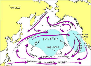 The Pacific States have coastlines along the North Pacific Subtropical Gyre, the largest ecosystem on Earth, located between the equator and 50° N latitude, and comprising about 8 million square miles.
Most Americans don't know what the Kuroshio Current is, much less why it is important. That is because it is critical to understanding the economic history of the Pacific States, so that history not taught in U.S. public schools.
In 1620 about 100 Puritan Separatist Pilgrim religious bigots settled the Plymouth Colony arriving on the Mayflower at what is now Cape Cod Bay, Massachusetts.
That year, 1620, was 100 years after Ferdinand Magellan discovered the Philippine Islands. And the Mayflower was 55 years after Miguel López de Legazpi established the first Spanish settlement in the Philippine Islands in 1565 seeking to develop trade between the East Indies and the growing Catholic Spanish colonies in the Americas across the Pacific Ocean.
In 1565 the Manila-Acapulco galleon trade finally began when Spanish navigators Alonso de Arellano and Andrés de Urdaneta discovered the eastward return route. Reasoning that the trade winds and currents of the Pacific might move in a gyre as was the case in the Atlantic, they sailed north to the 38th parallel off the east coast of Japan, before catching the Kuroshio Current and winds that would take them back across the Pacific. Reaching the west coast of North America, Urdaneta's ship the San Pedro reached the coast near Cape Mendocino, California, then followed the coast south to San Blas and later to Acapulco, arriving on October 8, 1565.
For 250 years - starting 49 years before the Pilgrims landed at Plymouth Rock and 205 years before the American Revolution - hundreds of Manila galleons traveled between the Asia and New Spain. That trade pattern has continued since, an additional 200 years, creating...
From that alone, one might infer that the "Pacific States" designation would reflect a substantive historical, cultural, economic, and physical separation from the area of the United States located east of the what we call the Transcontinental Divide.
"Mayflower" and "Pilgrims" have been terms drilled into U.S. school curriculums. Miguel López de Legazpi and the Philippine Islands not so much. Spain and Mexico, China and the Philippines, Japan and Korea are important to the Pacific States history and economy. Not so much Britain and France; essentially Europe, Africa, and the Middle East are less important to the Pacific States than they are to the rest of the United States. Ties to Latin America, East Asia, Southeast Asia, North Asia, Australia, New Zealand, and the Pacific Islands are far more important in the 21st Century.
Essentially, that requires a truly Progressive multicultural attitude sustained through Progressive policies and actions.
__________________________
*Tthe fact is that the 1790 Census counted white males and white females separately, plus all other free persons in a single category, and slaves in a single category. The United States Constitution Article 1 Section 8 also did not recognize indigenous people as being part of the new country. Before the Civil War most Black Americans were slaves but were included along with White in 1790 as a "13 Colonies Race." For purposes of allocating among the States seats in the House of Representatives, a slave was recognized by the United States Constitution Article 1 Section 8 as three-fifths of a person which endorsed the concept of black persons as less than persons, officially permitting white folks a point of reference - a black person is 60% of a real human. Today three U.S. States have majority populations that do not include their "13 Colonies Races" residents. Two are Pacific States, California and Hawaii, and the other state is New Mexico.